Preston Snoqualmie Regional Trail
Dog-friendly (on-leash), kid-friendly, historic, snow-free winter hikes, bike friendly, (no motorized bikes/vehicles)
Please note: King County regional trails allow Class 1 and Class 2 electric bikes and electric foot scooters. Riders must obey a strict 15 mph speed limit, yield to pedestrians, and wear a helmet. Class 3 e-bikes, gas or electric motorcycles, mopeds, and ATVs are completely banned from these shared-use regional trails.
Visit King County website for more info: King County Park Rules
 The Preston-Snoqualmie Trail is one of the Eastside's oldest paved rail trails, yet it remains off of the radar to many hikers and runners. Wedged between more popular parks and trails is part of the reason. The other is that the trail ends abruptly with no view or connection to a town or other trail.
Start from near its western terminus and head east. The trail, a former rail line for the Seattle, Lakeshore and Eastern Railway (from which Seattle's popular Burke-Gilman Trail was also born) begins a slow descent skirting below a handful of old homes from Preston's early mill town days. Pass a path and stairway on the right leading to the 1939 WPA built Preston Community Center. The trail then leaves the small town traversing steep lush forested slopes above the busy Preston-Fall City Road. Tall cedars, cottonwoods, maples and Sitka spruce line the way.
Unfortunately the old trestle once spanning the Preston-Fall City Road and the Raging River is long gone. So here the trail leaves the rail bed and steeply drops to cross the busy road. Use extreme caution as drivers frequently speed through this crossing. The trail then separated by a concrete barrier follows aside the road for a short distance before following the old road for a short distance. Cross the Raging River–then follow the road again for a short distance.
The trail then climbs via short switchbacks back to the rail bed. There is a small bench to sit and rest. The view has long since grown in. You can continue a short distance to an old trestle.
You can approach this trestle from the Lake Alice Trailhead and head north (see link for directions below). The information on the trestle from the King County website:
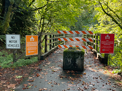
Preston-Snoqualmie Trail Bridge #2 (about 0.75 miles east of the Preston-Snoqualmie Trailhead parking lot) is closed indefinitely.
This bridge has been closed since it was severely damaged in a December 2022 storm, and despite extensive evaluation of all feasible options, King County Parks has not been able to identify a solution that can be permitted and constructed under current conditions. Please be assured that Parks remains committed to restoring connectivity in this area and will continue to explore long-term alternatives to improve access for trail users.
No detour is available at this time. The rest of the trail is still open for use in both directions.
Heading south from the Lake Alice Trailhead, the route continues to follow the railroad grade that used to come up from Issaquah, past Fall City and into Snoqualmie right next to the famous falls. The Lake Alice Rd trailhead is actually the historical location of the Fall City station. The route has some nice forest, a couple areas of territorial views and not much else. There is King County signage indicating "Falls Overlook", but there are currently no legal/safe views of the Snoqualmie Falls from this trail as the vegetation has grown in significantly over the years. There is a small area with three benches that provide a nice resting area before heading back to the parking lot.
Trailhead Locations/Directions:
- Issaquah Preston Trailhead: Google Maps
- Lake Alice Trailhead: Google Maps
- High Point Way Trailhead: Google Maps
- Detailed Information: Washington Trails Association
Dogs: On leash and we all appreciate owners cleaning up their dog poop (don't leave full bags on the trail).
Lake Alice Trailhead History: Railroad comes to Fall City